
rizole
It's not even my banana.
Now I have a credible night camera I've started taking more of an interest in places I can take it. Despite living in a relatively rural area, large metropoliton cities and conurbations are all over the place in my neck of the wood so light pollution is still an issue. Go up 3 or 400meters and I can see the glow of Manchester in one direction and Bradford and Leeds in another.
So this map of light pollution will come in handy when we can all move around again, maybe by spring/summer perhaps.
 www.nightblight.cpre.org.uk
And for those of you not in my part of the world I found this.
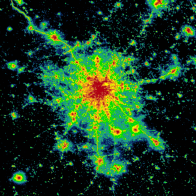 www.lightpollutionmap.info
So this map of light pollution will come in handy when we can all move around again, maybe by spring/summer perhaps.
Home - CPRE
We are CPRE, the countryside charity. Learn how we're working for a beautiful, thriving countryside for everyone - and how to get involved.
And for those of you not in my part of the world I found this.
Light pollution map
Interactive world light pollution map. The map uses NASA VIIRS, World Atlas 2015, Aurora prediction, observatories, clouds and SQM/SQC overlay contributed by users.
www.lightpollutionmap.info
Last edited: